


While winter has its drawbacks, it can still be a great time to get outdoors and enjoy the natural world. The heartiest among us don’t mind a bit of chill, but almost anyone can find relatively warm afternoons a good time to hike this time of year.
The barren trees and broad views actually can be considered an improvement for the three-mile loop trail at Glassberg (Myron and Sonya) Family Conservation Area in far northwest Jefferson County. Its signature Meramec River scenic overlook, which is worth the visit any time of the year, benefits from the unobstructed horizon.
The trail explores about half of the 634-acre recreation area. Its 300 feet of elevation change is mostly gradual, and the back half of the trail follows ridge lines for the majority of its length. There are enough climbs to remind you that it is hiking and not just a walk in the park, but the trail was well marked and worn when we visited in the fall.
Other than a couple of small clearings, the majority of the property is typical Missouri Ozark oak and hickory forest. About 500 feet from the parking lot on Highway FF, the loop branches. If you choose to stay to the right, you reach the scenic overlook in just over a mile. The entire walk is uphill, but only a couple of spots seem steep. The views both up and downstream are worth the effort.
Retracing your steps from the river view back down the hill would shorten the walk to about two miles rather than three, and would avoid a couple of ups and downs featured on the back half of the loop. If the walk up seems like too much, this might be a recommended alternative.
Hikers who choose the full loop are rewarded by a long north-south ridgetop walk with good valley views on both sides of the trail. When the hike turns back toward the parking area, the trip down is interrupted only by one short climb.
The state Department of Conservation official area map does not indicate a trail to a 3-acre fishing lake on the site, but other online hiking platforms do show an internal loop. The alltrails.com comment board includes reviews that indicate the trail is not well marked or always passable. We took a quick look at the path and passed on trying it. Maybe future development at the area will add better access to the pond.
The western half of the conservation area does not include trails, but does provide remote sites for archery hunters. Shotgun hunting for turkeys, squirrels and other upland game is permitted as well, but is not as prevalent as deer hunters with bow and arrows.
The area is closed from 10 p.m. to 4 a.m., and bicycles and horseback riding are prohibited. All pets must be on a leash.
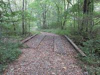
The Glassberg area is part of an overall effort to protect the Labarque Creek watershed in Jefferson County. One stream crossing along the trail drains to Labarque Creek in the adjacent Hilda Young Conservation Area.
LaBarque Creek is more than six miles of permanently flowing stream. It supports 52 species of fish with an underlying sandstone geology that produces dramatic landscapes, including steep, narrow valleys, canyons, bluffs and shelter caves.
The LaBarque watershed encompasses about 13 square miles and more than half of the area is publicly owned, including three conservation department properties and the 800-plus acre Don Robinson State Park, which is owned and managed by the state Department of Natural Resources.
The Glassberg Family Conservation Area is on Highway FF, less than a half mile from John McKeever Road.
John Winkelman is Marketing Director for Liguori Publications near Barnhart, Mo., and Associate Editor for Outdoor Guide Magazine. If you have story ideas to share for the Leader outdoor news page, e-mail ogmjohnw@aol.com, and you can find more outdoor news and updates at johnjwink.com.