


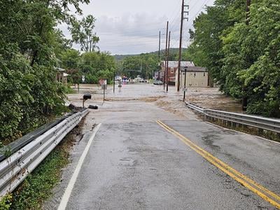
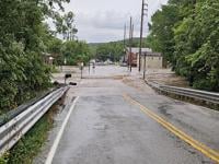
Flash flooding on Monday evening, July 8, trapped children and adults at a day care facility in House Springs and forced some residents in a nearby mobile home park to evacuate, High Ridge Fire Protection District Chief John Barton said.
The Northwest R-1 School District also was affected by flash flooding, as was a neighborhood off Seckman Road in Imperial, officials reported.
Barton said High Ridge Fire crews were out evacuating people from subdivisions near Hwy. 30 and Hwy. MM at about 4:30 p.m. Monday when Big River tributaries rapidly rose during the sudden downpour.
Chris Short, pastor at Grace Pointe Church of God and director at Apple of His Eye Daycare, said the water came up to the church’s driveway and parents were unable to pick up their children. The day care is operated out of the church near Hwy. MM and Gravois Road.
Short said all children and staff members were able to leave at about 6:45 p.m. Monday after the floodwaters went down.
“We could see across the street that our neighbors had a lot of water going through their yard, a terrible amount of water,” she said. “We just kept the children in the upstairs part of the day care and kept them safe, fed them dinner and kept taking care of them until their parents could get there.”
Cedar Hill Fire Protection District Chief Mick Fischer estimated the House Springs area saw 4 to 6 inches of rain within 30 minutes on Monday.
Fischer said his crews advised the day care staff to keep the children inside the church during the flash flooding.
“It’s tough in those situations because people feel like they need to get out of there, but what we knew, or anticipated, was that the water wouldn’t get that high (to the day care), so instead of putting all those little kids on a boat, we told them they’re safe where they’re at right now,” Fischer said.
Short said Cedar Hill Fire’s rescue boats were stationed on each side of the building if parents needed to get inside the building.
Barton said people who live in the Lakeherst Mobile Home Park off Indian Springs Road between Hwy. 30 and Gravois Road voluntarily evacuated during the flash flooding.
He said some residents went to family members’ homes, while others remained in the area and waited for the water to recede.
“It’s pretty significant flooding,” Barton said this morning, July 9. “It’s the worst I’ve ever seen in our district. There were places flooded yesterday that I’ve never seen flooded before. It was fast-rising water. The ground was saturated. The water came up really fast and caught a lot of people off guard.”
The Big River near Byrnesville is expected to crest at approximately 18.8 feet at about 1 a.m. Wednesday, according to the National Oceanic and Atmospheric Administration (NOAA). Minor flooding occurs in the area when the water levels rise about 16 feet, and moderate flooding occurs when the water levels rise above 20 feet.
Northwest school district deals with flash flooding
Northwest R-1 School District Superintendent Jennifer Hecktor said Monday’s flash flooding led to water getting into Valley Middle School in House Springs and the nearby Administration Center and a nearby warehouse.
She said the flooding began about 5 p.m. when water rushed over Gravois Road, which regularly occurs. In addition, a creek behind the school rose, contributing to the flooding.
Hecktor said the creek had not risen that high in about 20 years.
She said between 2 and 3 inches of water got into the ancillary gym at Valley Middle, about 3 inches got into the Administration Center and about 3 feet of water got into the warehouse.
The water came up quickly and receded quickly, Hecktor added.
She said the school district contacted a restoration company called First Onsite to help clean up after the flooding.
Hecktor said doors to the school had to be left open while the restoration work was going on, so extra security was needed to keep an eye on it.
Jefferson County Sheriff Dave Marshak said Hecktor contacted his office on Monday evening to report the flooding, and deputies responded to Valley Middle.
“With several unknown people sightseeing in the waters around the school, Superintendent Jennifer Hecktor was concerned, so we coordinated for additional security throughout the night,” he said. “We continue to work with the district to make sure the district is protected. We had no other major security or public safety issues that I’m aware of.”
Hecktor said she appreciated the district’s custodial and maintenance staff who worked through the night to deal with the flooding and make sure the building was secure.
Imperial subdivision also sees flash flooding
Warren Robinson, director of Jefferson County Office of Emergency Management, said a resident of the Summerfield Parkside Estates subdivision off Seckman Road in Imperial contacted his office because of floodwater from the Rock Creek.
“Flash flooding is difficult because there is not much we can do about that,” he said. “That is an area we have received information about. I am sure we will look at that to see if there is anything that can be done.”
Jefferson County 911 Dispatch Chief Travis Williams said it was unfortunate that they heavy rain moved into the area when many people were headed home from work. However, the timing helped with staffing at Jefferson County 911.
“It happened during drive time with a lot of people trying to get home, but it was also during a shift change for us,” he said. “We were able to keep a couple of dispatchers from the day shift over into the night shift to provide extra coverage.”
Williams said call volume was up by 30 to 40 calls between 4:30 p.m. and 7:30 p.m. Monday, adding that Hwy. 30 and Gravois Road in the House Springs area were under water for part of that time.
He also said 911 received numerous calls about live power lines being down in the area.
“We had resources tied up on live power lines and doing water rescue,” he said. “It definitely created pandemonium for a couple of hours.”
Tropical Storm Beryl
The National Weather Service reported there may be between 1 to 3 inches of rain throughout the St. Louis area today with possible higher amounts in portions of Jefferson County.
The heavy rains are the result of Tropical Storm Beryl making landfall in Texas as a Category 1 hurricane early Monday morning. The rain is expected to continue throughout the area today and into Wednesday morning, July 10.
A flood watch is in effect until 4 a.m. Wednesday.
“If the track of the storm moves further south, we will not be as affected,” Williams said. “If it stays on its current trajectory, we could see some flooding issues happening in the county.”
Robinson said his department is monitoring the weather today to see if any heavy bands of rainfall come through the county.
“With the soil already saturated the way it is, if we get another heavy band of rainfall, we could be looking at some additional flash flooding issues,” he said. “That is the primary concern we have for today.”
Robinson said based on predicted river levels for the Big and Meramec rivers, there does not appear to be a threat of major flooding in the county.
“(The rivers) are forecasted only to make it up to minor flood stage, and we are hoping that holds true,” he said. “That has not traditionally led to many issues for us in the past.”
Williams said residents should continue to monitor weather reports and avoid driving where water is on roadways.
“It is not worth it to drive through it,” he said. “It doesn’t take a whole lot of water to wash a vehicle off the road or make it stall out. If there is water standing on the roadway or running over the roadway, you better turn around and find another route.”
Williams said Jefferson County 911 will have additional staff for the next two days.
“We are ready for whatever comes our way,” he said.
Barton said his crews expect more water evacuations today and Wednesday. He said residents in flood areas who need assistance are encouraged to call 911.
“If we get a significant amount of rainfall in a short period like we did yesterday, we definitely anticipate more flash flooding in the area,” he said. “A lot of times people try to walk through floodwaters, but it’s easier for us to get there with a boat and get them out safely. We have concerns about debris in the water and power lines in the water.”
Herculaneum
Herculaneum Fire Department Chief Kevin Baker said the city had no major flooding issues as of this morning, and he does not expect any.
The NOAA is predicting the Mississippi River to crest at approximately 29.4 feet at about 7 a.m. Wednesday near Herculaneum. Minor flooding occurs in the area when water levels rise above 26 feet and moderate flooding occurs about 32 feet.
Baker said the Mississippi River would need to rise several more feet before water would come over the bridge on Hwy. 61/67 (Commercial Boulevard) over Joachim Creek in Herculaneum.
“It will depend on how much rain actually falls and where things stay,” he said. “Other than that, we don’t have a lot of swift water because we have the Joachim that leads right into the Mississippi. There is not a lot of flash flooding for us.”
Kimmswick
Mayor Phil Stang said there were no major concerns about flooding this morning in the Mississippi River town.
“The water is high, but it is substantially below our north floodgate, which is when we would have to start to do something,” he said. “We are prepared. We have all of the support services lined up in case it should go higher.”
Arnold
Arnold City Administrator Bryan Richison said tree limbs and leaves fell in portions of Arnold on Monday, but no major incidents were reported.
“It seems scattered,” he said. “It does not seem like one area got hit really bad. It is mostly a bunch of leaves, some smaller branches and occasionally some bigger branches.”
The NOAA is predicting the Meramec River to crest at approximately 30.6 feet at about 1 a.m. Thursday, July 11, near Arnold. Minor flooding occurs in the area when water levels rise above 24 feet and moderate flooding occurs about 35 feet.
“Some of the more remote areas of (Arnold City Park) may start to get water, but I don’t think it will get high enough to get close to any houses,” Richison said. “There may be a little water in Pomme Creek Park, but even when the Pomme Creek goes under, it doesn’t affect houses.”