


All conversations about rails-to-trails conversions in our state begin with the story of the Missouri-Kansas-Texas Railroad corridor. The MKT rail line property is now the 240-mile Katy Trail State Park from near the confluence of the Missouri and Mississippi rivers to Clinton, southeast of Kansas City.
Acknowledged since 2008 by the national Rails To Trails Conservancy’s Hall of Fame, the Katy accounts for more than half of the converted miles in Missouri, but it is not the only former rail line that hosts bikers and hikers. The state has 26 rail-trails and 16 projects for more than 400 more potential miles.
The non-profit conservancy advocates for conversion nationwide. The US has more than 2,400 rail trails that provide access to nearly 26,000 miles of developed hiking, according to railstotrails.org. This year the organization will celebrate its 40th anniversary on Celebrate Trails Day, April 25.
Obviously there are many opportunities to find a trail for hiking any time of the year, but the Katy stands out from the crowd as the longest in the nation. With 26 official trailheads and countless private accesses, Missouri State Parks also highlights four fully restored railroad depots along the way.
We recently visited the most convenient places in the St. Louis area to experience the Katy Trail. The St. Charles Riverfront offers easy access and ample services to support users. The historic Main Street shops provide a lure to get even the most reluctant hikers to try a few strides on the trail.
The other handy spot in the region to climb aboard is in the Augusta and Defiance area, which is notable for its wine country attractions. We caught the Katy at the Matson Trail Head parking lot along Highway 94 and then rewarded our workout with a cold bottle at the nearby Sugar Creek Winery.
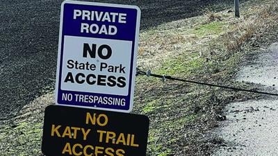
The one place we couldn’t take our walk was in the tiny town of Machens where the trail and state park officially begins. Even though it appears on Google maps that a public street can get you to the eastern trail terminus, roadside signs say something different. We even set off alarm sirens when we stepped out to take a photograph.
The nearest public access to reach the end of the line is at a wide spot on Music Ferry Road called the Black Walnut Trailhead. It’s a 3.1-mile trek from that trailhead to the official starting point, meaning that the roundtrip hike would be six-plus miles. That may be an easy ride for the many bicyclists who use the trail, but it’s a commitment for walkers.
Rail trails are ideal for multi-users. In addition to the impressive length, the former train track easements provide plenty of width for safe passing. We saw several cyclists enjoying their rides, and all the encounters were friendly. The former rail lines also operated on subtle grade and elevation changes as they frequently follow stream valleys.
Another popular route in the St. Louis area is the 9.9-mile former Kirkwood-Carondelet branch of the Missouri Pacific Railroad line. It is known today as Grant’s Trail and passes through the property once owned by the famous Civil War general and 18th president of the United States.
On a recent trip to Springfield, Missouri, we found several rail trail projects including a hike along the Dry Sac River at the Lost Hill Park north of town. For the more adventurous, The Frisco Highline Trail is a 37.5-mile trail on a former rail line connecting Bolivar and Springfield.
The idea to convert former rail lines into hiking and biking trails may have had some initial detractors, but it has become a 40-year success story locally and across the country.
John Winkelman has been writing about outdoors news and issues in Jefferson County for more than 30 years and was the Associate Editor for Outdoor Guide Magazine. If you have story ideas for the Leader outdoor news page, e-mail ogmjohnw@aol.com, and you can find more outdoor news and updates at johnjwink.com.