


The lines are being redrawn.
Political subdivisions – from the U.S. Congress on down to water supply districts – are required to redraw districts every decade after receiving population information from the U.S. Census Bureau.
Sometimes the process is simple. Other times, it can be contentious.
Generally, the higher the office – and the more that partisan politics plays a role – the more debate that’s generated.
That’s certainly the case with a map of Missouri’s eight seats in the U.S. House of Representatives, with the Missouri Senate set to resume tussling that issue this week after being derailed because of winter storms last week.
Those closer to home who were tasked with redrawing the county’s council districts didn’t have so much trouble coming to a consensus.
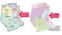
Jefferson County Council
The County Council voted unanimously at a Jan. 31 special meeting to approve new maps for the county’s seven council districts.
Under the county charter, every 10 years, council members must nominate a Republican and a Democrat from their district to serve on a redistricting committee, which is charged with coming up with a redrawn map of districts. Once that panel completes its work and submits it to the county, the County Council has 10 days to approve it.
Alan Leaderbrand, who chaired the county redistricting panel, said while the process took some time, the goal of the committee was simple.
“We wanted to divide up the county seven ways, with about the same number of people in each of the seven parts,” he said.
Under the county charter, there cannot be more than a 10 percent deviation from the smallest to the largest district in terms of population.
Leaderbrand said the committee achieved that goal, with only an 8.37 percent difference between the smallest, District 1 (with 30,698 people), and the largest, District 7 (with 33,266).
The Census figures showed that six of the seven current council districts picked up people, with only District 5 shedding population, down 1,622 over the last decade.
Leaderbrand said the county’s Planning Division and Geographic Information System staff helped develop initial maps, and then he “tweaked it some more” for about four hours before presenting it to the other redistricting commission members.
“There weren’t a whole lot of changes, but there was a little debate,” he said.
Leaderbrand said the goal of the commission was to keep Census tracts, or relatively small areas grouped together by the Census Bureau, together.
However, he said, the representatives from Districts 1 and 7 contended they wanted to keep the lines between those western Jefferson County districts the same as they have been for the past 10 years, so four of those tracts were split.
“It was a challenge to get the districts to the same population,” he said.
To account for the loss of population in District 5, most of Pevely was moved into District 4.
In addition, the city of Hillsboro, which formerly was contained within District 6, is now split between districts 6 and 7, with Business 21 the dividing line.
“We tried to keep everything the way it was as best we could,” Leaderbrand said, “but it was impossible to do that and avoid splitting Census tracts.”
Leaderbrand said he was relieved the County Council approved the map.
“I hope that means everybody was happy with it,” he said. “This was a lot of work, but I’d do it again if I’m still around in 10 years.”
U.S. Congress
State Rep. Dan Shaul (R-Imperial) is chairman of the House Redistricting Committee that was charged with realigning Missouri’s eight congressional districts.
His panel’s map, which maintained the current ratio of six seats currently held by Republicans to two now held by Democrats, was approved by the full Missouri House and passed through a Senate committee. It now awaits a vote by the full Senate. Approval would send the legislation to Gov. Mike Parson’s desk to become law.
“They (the Senate) are trying to work through some issues, trying to determine whether they want to accept what we sent them or make some modifications,” Shaul said.
Some Republican senators want to see one of the two current Democratic seats, a Kansas City-area district now held by Emanuel Cleaver, carved up and the pieces spliced onto rural areas that lean Republican.
Others are concerned the district now held by Republican Ann Wagner, which includes Jefferson County but wouldn’t under the map that Shaul is championing, is not “safe” enough to ensure her re-election and want it modified.
Some Senate Democrats, on the other hand, are arguing that the 6-2 split doesn’t accurately reflect the political bent of Missourians, judging by voting in statewide elections. They contend that a 5-3 Republican advantage would be a more accurate reflection.
Shaul said he would prefer the Senate approve the map that was sent to them.
“I think the map treats Jefferson County very well. Instead of having three districts, there’s only one, benefiting our status as a population center and allowing Jefferson County residents to have an influence on who their representative will be,” he said. “Blaine Leutkemeyer (District 2, St. Elizabeth) has done a great job representing the part of Jefferson County that he has, and I expect that he’ll do the same for the entire county.”
Shaul said he hasn’t liked some of the proposals going around the Senate.
“Some maps I’ve seen have Jefferson County and (parts of) St. Louis County in the same district, like in the old days with (Richard) Gephardt and (Russ) Carnahan. I think COVID has put a spotlight on the differences between St. Louis County and Jefferson County. Putting us in the same district would be a disservice to both. I don’t want to see (St. Louis County Executive) Sam Page influence what goes on in Jefferson County.”
The Senate was scheduled to continue debate on the redistricting issue when it reconvenes this week.
“The Senate does things a lot differently than the House, but the more time they spend on this issue, the less time they have on other, very important issues that have come out of my election committee, like photo ID requirements and referendum reform. People have said they want these things.”
This year’s legislative session is scheduled to close on May 13.
Missouri House
While Shaul was not involved in the redistricting of the 163-seat Missouri House of Representatives, he said he’s happy with the map that was approved by an independent, bipartisan 20-member citizens commission charged with the chore.
“I think they did a good job. It’s tough to work together to come up with a common goal, and I think it’s great they came up with something they found acceptable.
“There were a few changes in Jefferson County, but overall, I think it is good for the county. My district is still a great district. While no one likes changes, the panel had to account for population shifts.”
The new map gives Jefferson County six state House districts, all of which are fully within the county. Currently, the county shares District 97 (now held by Republican Mary Elizabeth Coleman of Arnold) with south St. Louis County; District 115 (now held by Republican Cyndi Buchheit-Courtway of Festus) with St. Francois and Ste. Genevieve counties; and District 118 (now held by Republican Mike McGirl of Potosi) with Washington County. It also has four districts that do not cross county lines.
“A lot of people from Jefferson County tell me they like it,” Shaul said. “Statewide, not everybody’s going to be happy, but you try to draw 163 districts and make everybody happy.”
Missouri Senate
A different 20-member independent bipartisan citizens commission that met to redraw the state’s 34 Senate districts wasn’t able to reach a consensus to submit a preliminary map to the Missouri Secretary of State’s Office before the Dec. 23 deadline.
Under state law, the chore of redrawing the Senate maps now falls to a group of six appellate court judges.
“It was a mess from the get-go,” said Shaul, who cannot run for re-election for his Missouri House seat and has announced his plans to run for the Missouri Senate.
Jefferson County currently has two representatives in the state Senate, both Republicans: Paul Wieland of Imperial (District 22, which now covers the northern half of the county) and Gary Romine of Farmington (District 3, which includes the southern half of Jefferson County along with Iron, Reynolds, St. Francois, Ste. Genevieve and Washington counties).
Shaul, along with Coleman and Jeff Roorda, all have announced plans to run for the Republican nomination for the area now represented by Wieland, who also is term-limited.
“I hope they decide what they’re going to do soon,” Shaul said. “I can see the 22nd District perhaps get a little smaller (because of increased population density in the northern part of the county), but I hope it doesn’t change drastically.”
Filing for the August primary runs from Feb. 22 through March 29, so presumably the districts will be set by the opening of filing.
“It will be nice to have that behind us,” Shaul said. “It will be a step toward having a good election in November.”