


The Big River at Cedar Hill is expected to crest at 27 feet Wednesday, Nov. 6, at 6 p.m., which would be the eighth-highest crest ever recorded in the area, according to the National Oceanic and Atmospheric Administration (NOAA).
Cedar Hill Fire Protection District Chief Mick Fischer said residents living along the river should evacuate immediately.
According to NOAA, the Big River at Cedar Hill was at 20.85 feet as of 12:45 p.m. Tuesday, Nov. 5.
The highest the Big River at Cedar Hill has ever reached was 30.20 feet on Aug. 21, 1915.
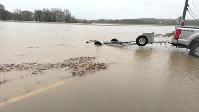
At 1:30 p.m. Nov. 5, Fischer said many roads are closed in his fire district due to flooding. Cedar Hill Fire and the Missouri State Highway Water Patrol were evacuating families on Stovesand Road earlier in the day, he said.
“The Big River is flooded, it’s out of its banks and there are a bunch of roads closed,” Fischer said. “It’s starting to surround some houses. At this point, we’re trying to get the people who live in the area impacted by Big River flooding to understand how much water we’re going to get, and how much the river is expected to rise. We want them to voluntarily evacuate before we have to go get them in our boat.”
Fischer said he is working with Jefferson County 911 Dispatch to send a flood warning to residents who live along the river via the Everbridge emergency notification system. He said the district can’t force people to leave their homes, but doing so would make everyone safer.
“We’re having to send out an Everbridge notification to people in those areas to prepare to evacuate, and really at this point, that’s all we can do,” Fischer said. “(Evacuation) is not only for their safety but our safety, too. If we can get them to leave now, where they can get their cars out and whatever belongings they want to take with them, that’s much better for them than us coming and saying, ‘We’re here to get you, you’re not bringing your stuff.’”
Flash flooding in House Springs
High Ridge Fire Protection District Chief John Barton said crews were out early on Nov. 5 evacuating families along Hillsboro-House Springs Road in House Springs due to flash flooding. The Bourne Creek, which flows parallel to the road, was the cause of the flooding, Barton said.
Barton said the rescues began at about 2:45 a.m. and finished at about 7:30 a.m. when the water began to recede.
“We checked all the residences that were at risk of flooding or had water already inside of them,” Barton said. “We evacuated people who wanted to leave. I would estimate in some areas the water was up to 5 feet high – it was reaching the firefighters’ chests.”
Barton said he wasn’t aware of any residents needing medical treatment after being evacuated.
He said crews were concerned with loose propane tanks which could pose a potential risk if they floated away in the flood and became damaged.
“We had problems with a lot of propane tanks overturning or breaking free of their mounts and floating in the floodwater,” Barton said. “We had to shut the propane off to several residences. We found one that had broken free and was upside down in several feet of water several houses down from where it came from.”
Potential flooding in Eureka
NOAA predicts that the Meramec River near Eureka will reach a “major” crest of 37.60 feet at noon on Friday, Nov. 8. Currently, the river is at a “minor” level of 18.83 feet.
The highest the Meramec River has ever reached near Eureka was 46.11 feet on May 3, 2017.